On Trevor Paglen
Artist Trevor Paglen has built a career adopting cartography and political geography as tools to interrogate contemporary surveillance culture. Paglen's artwork serves as a form of resistance against official narratives on what can be seen, documented, or mapped. This body of work mapping dark sites and hidden data infrastructure simultaneously exposes and subverts the power structures behind mass surveillance, blurs hard notions about borders and territories, and challenges expectations on the limitations of human perception. Paglen’s praxis includes photography, mapping, and sculpture intended to unveil the concealed aspects of our global landscape. Early in his career, Paglen chose to adopt the methods of a geographer (geospatial tools, remote sensing, landscape photography, and mapping) as resistance to pervasive surveillance and state secrecy. His work reveals coded truths hidden within conventional maps and landscapes, and encourages audiences to reconceptualize the way the mapped world is perceived. In his 2010 book, Invisible, Paglen explained this lifelong project to serve as a taxonomy of visible human knowledge:
There are the things we know we see
There are the things we know we do not see
There are the things we do not know we do not see
And finally, there are the things in plain sight we choose not to see, or repress.
Consider Paglen’s documentation of CIA surveillance satellites in astrophotographs taken with the aid of crowdsourced sky maps showing “dark” satellites unlisted in public records.
Trevor Paglen, LACROSS/ONYX V Crossing The Disk of the Moon (Radar Imagine Reconnaissance Satellite, USA 182), 2007
animation by Joel Silverman
The secret reconnaissance satellite captured above is detectible not as an object, but only as an aberrant pixel on a thoroughly mapped moon. The moon was first thoroughly sketched in 1836 by German astronomer Johann Heinrich von Mädler, who drew the conclusion that the moon has unchanging features with no oceans, and thus could be mapped, in his Mappa Selenographica. Because the moon was mapped, a photograph departing from this map forms a counter-map and thus reveals a hidden truth. This is the core of Paglen’s method, using a blend of photography and thorough research to capture details of elusive sites and military installations, and thereby providing a visual and analytical entry into spaces that are typically inaccessible to the general population. His work provides a whistleblower’s insight into the existence of these concealed locations. Paglen asks the viewer to consider the implications of concealed activities in the context of their military justifications. These space technologies were developed primarily to facilitate the nuclear arms race and as such are explicit evidence of human genocidal and geocidal violence. In recent decades, space technology has mutated into tools of spycraft, with geostationary eavesdropping and data-relay satellites orbiting Earth at an altitude of 35,786 km. This leads to Paglen’s parallel concern of providing evidence of the erosion of civil liberties amid society’s debate over transparency and secrecy. Frank Stella famously stated of his Minimalist work, “What you see is what you see”, but Paglen could be said to take the opposite as a motto. What is seen is just the beginning in this body of work scrutinizing the world for icebergs visible only by their tips.
Paglen's critical cartography serves as a form of resistance against the human rights abuses that are collateral consequences of unfettered state and military secrecy. His 2012 book project Blank Spots on the Map is a broad look at U.S. secrecy and historical geography of what intelligence insiders call “the world,” referring to the covert state within the state that has grown during the military-industrial era since World War II.
Paglen writes:
“[the] constitutive economic, legal, social, and spatial dynamics constitute a "geography" of secrecy; and that the geography of state secrecy is rife with ever increasing numbers of internal contradictions whose continual management requires the secret state to continually expand.”
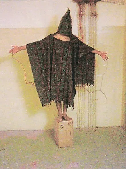
Paglen cites former President Barack Obama quoting, skeptically, Supreme Court Justice Louis D. Brandeis’s maxim, “Sunlight is said to be the best of disinfectants; electric light the most efficient policeman.” to be a pollyannaish dream that the dark side of intelligence could be constrained through disclosure. Paglen argues that when secret and illegal projects are made public, the system simply shifts to accommodate the objectives of these projects in sanitized but equally objectionable ways. For example, the methods of U.S. Army intelligence gathering during the 2003 Iraq War drew global condemnation when a whistleblower disclosed cell phone photographs documenting members of the United States Army and the CIA committing human rights violations and war crimes against detainees in the Abu Ghraib prison in Iraq, including physical abuse, sexual humiliation, torture, and sexual violence.
Whistleblower-sourced cell phone photograph of prisoner Abdou Hussain Saad Faleh being tortured by the CIA, 2004
Global and domestic horror at these photographic revelations led to military and intelligence reform commissions, but nonetheless the decades ahead have seen the U.S. military engage in torture in the Guantanamo Bay Detention Camp in Cuba, the torture merely callibrated down to less-dramatic waterboarding, stress positions, and solitary confinement.
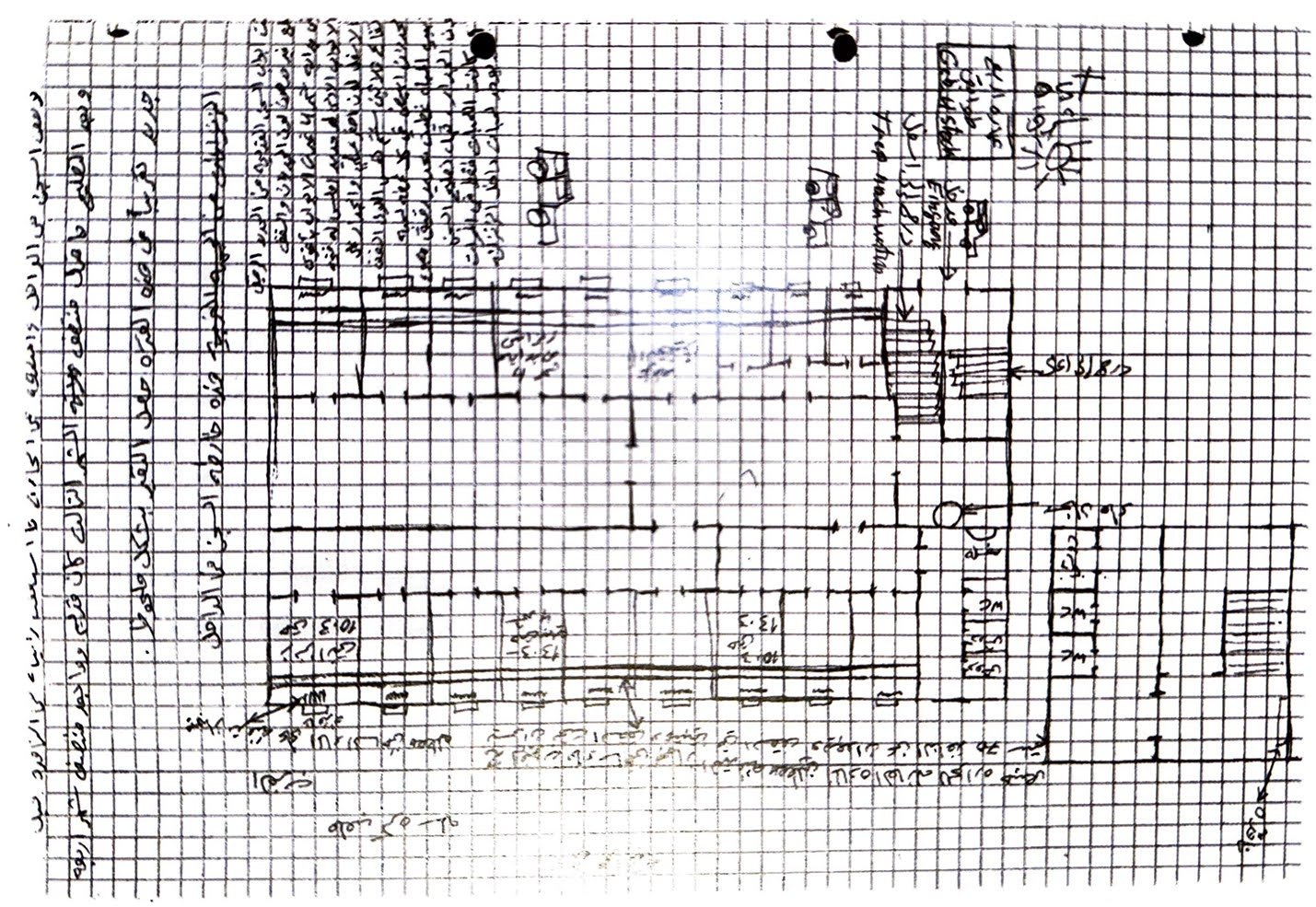
Paglen is most known as a photographer, but the gravity and complexity of his subject led him to earn a Ph.D. in geography after art school. Blank Spots on the Map accordingly has no photographs, only meticulously-researched text. Paglen's research-driven approach exposes a world with untold secrets that typically go undisclosed. The information age is considered to be a new era of transparency, but Paglen pokes until he finds the most opaque corners, identifying "blank spots" to present a rarely-seen view of the Pentagon's operations. Blank Spots encourages readers to consider the broader implications of concealment in contemporary society. The work speaks to the impossibility of uncovering truths in complex institutional structures, asking the public to debate the balance between security and secrecy. Elsewhere in Blank Spots on the Map, Paglen cites Guantanamo Bay and the power of victim memory maps to prove the CIA’s practice of “extraordinary rendition” as legally sanctioned acts of torture and deprivations of due process of law in the name of the fight against terrorism. The book reproduces a map drawn by extraordinary rendition victim Khaled El-Masri depicting the CIA’s secret SALT PIT prison where he was held. El-Masri is a German and Lebanese citizen who was mistakenly abducted by the Macedonian police in 2003 and handed over to the U.S. Central Intelligence Agency (CIA). While in CIA custody, he was flown to Afghanistan, where he was held at a site and interrogated, beaten, strip-searched, subject to sexual violence, and subjected to other forms of torture. After El-Masri held hunger strikes, and was detained for four months in the "Salt Pit", shown below, the CIA finally admitted his arrest was a mistake and released him. A 2012 European Court of Human Rights ruling concerning El-Masri’s detention marked the first time that CIA activities against detainees had been legally declared as torture.
Paglen’s reproduction of a map drawn by extraordinary rendition victim Khaled El-Masri depicting the CIA’s secret SALT PIT prison here he was held
Paglen’s work has long highlighted the subversive potential of mapping as a form of surveillance critique. His photograph of a covert satellite against the moon both uncovered hidden agendas of global surveillance but also questioned the ethics of photographic observation and privacy. Paglen’s Blank Spots on the Map revealed the geographies of secrecy, challenging viewers to reconsider the narratives endorsed by state powers and hidden in plain sight. Paglen’s visual documentation of CIA surveillance satellites in astrophotographs exposed the intrusive reach of modern surveillance technologies, further destabilizing the supposed objectivity of traditional maps.

